In March 2020, as the Western world began its quarantine due to COVID-19, Caracas was filled with smoke. Helena Carpio, a journalist specializing in the environment, leaned out of her window and she was shocked to realize that the haze prevented her from seeing Ávila, the emblematic mountain that borders the Venezuelan capital.
There were no flames to be seen either. Something was burning, but no one knew where and there was no official information about it. Twitter was the only place to find information and she only saw messages from hundreds of people complaining about the consequences of smoke: chest pain, shortness of breath, itching and burning in the eyes, among others.
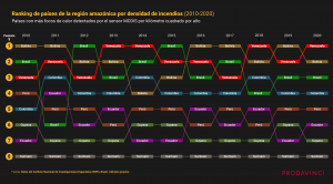
Ranking of countries in the Amazon region by density of fires between 2010 and 2020 ("Naturaleza en Llamas" by Prodavinci)
“It was very exasperating to look out the window and not see flames anywhere. It was known that something large was burning, but we had no idea what it was. Googling, I came across the Global Forest Watch map and started looking for what data was feeding that map. This is how Naturaleza en Llamas (Nature in Flames) arose,” Carpio told LatAm Journalism Review (LJR).
"Nature in flames: 20 years of fires in protected areas of Venezuela" is an investigation by the Venezuelan digital magazine Prodavinci and was led by Carpio. This project analyzed two decades of satellite data on hotspots to understand the when, where and why of forest fires in all national parks, natural monuments, and other protected areas of Venezuela that correspond to natural spaces protected for their biodiversity.
The main findings of this investigation include that, in 2020, Venezuela was the country in the Amazon region with the highest density of fires (almost double that of Brazil). In addition, in the last 20 years, hotspots increased in 63 of the 80 protected areas of the South American country, with 2020 being its worst year of fires on record.
No official records
In Venezuela, there is no law on access to information and transparency. For years, non-governmental organizations and media outlets have denounced the existing opacity and lack of official information. Up-to-date data on the economy, health and much less the environment, are not published.
There is also no public system that monitors fires in Venezuela. According to Carpio, there should be a record of when a fire occurs in the country, but that is not happening. The journalist explains that, previously, each Protected Area had a person responsible for monitoring fires. However, as the country ran out of resources, it stopped providing helicopters for monitoring and stopped investing in a prevention system, and those in charge of many areas left their posts due to precarious salaries, Carpio explained.
Therefore, using satellite data was the only way the Prodavinci team came up with to understand what was happening. They downloaded data corresponding to 20 years of hotspots in Venezuela from the Moderate Resolution Imaging Spectroradiometer (MODIS) and the Visible Infrared Imaging Radiometer Suite (VIIRS), data that correspond to NASA in the U.S.. This data was then statistically analyzed and viewed on geographic information platforms.
This is not the first data-driven project that Prodavinci has carried out.
“As journalists we are quite used to opacity in Venezuela. There are no data. So we are always looking for new ways of quantifying the issues even if they are complex," Carpio said.
In 2018, the site published the investigation “Vivir sin agua” (Living without water) where it managed to determine how many hours of water a week Venezuelans received in their homes, based on rationing plans published by the government in non-reusable formats. They transcribed the documents, crossed them with population information, and developed a methodology to standardize the parameters of the plans. This work won the 2019 Monsignor Pellín Prize and first place in the 2019 IPYS National Contest of Investigative Journalism..
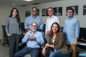
The Prodavinci team (Courtesy)
In 2019, Prodavinci published "Las horas oscuras" (The Dark Hours) in which it followed the same scheme from the previous project, but this time using an optical character recognition (OCR) software. They managed to calculate that 18.42 million Venezuelans lived in counties parishes subjected to electricity rationing plans. This investigation was a finalist for the award for access to public information from the Office of the Special Rapporteur for Freedom of Expression of the Inter-American Commission on Human Rights.
Finding databases with information about Venezuela does not always happen. Most of the time, journalists have to build their own spreadsheets, gathering unofficial information. However, Carpio says that in her newsroom, the team views with great emotion the potential that the use of technology has within its investigations, even more so in a context where transparency is lacking.
“Technology has changed our landscape. Perhaps, a few years ago, analyzing data with thousands of entries could have been very difficult, especially being a small media outlet with few resources. But, now using geographic information or OCR apps, you can do it in a week and you don't need 30 people working,” she said.
Synergy between journalists and academics
"Nature in Flames" had support from two fundamental sources: Venezuelan academia, which provided expert help and information, and the Amazon Rainforest Journalism Fund, an initiative of the Pulitzer Center for Journalism, which provided financial support.
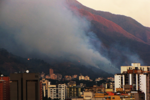
Fire in 2010 at El Ávila Mountain in Caracas, Venezuela (Photo: Cristóbal Alvarado Minic/CC BY 2.0)
Carpio pointed out that in the project, they transferred the methodology that is usually used in academia to journalism.
“Environmental issues are such complex issues, so multivariate, with so many details that I feel that the only responsible way to address them is by collaborating with academia,” Carpio explained during a video call. “This is work that perhaps could not have been done without the experts and the experts might not have been able to do it without the journalists. It was a team effort, from both sides and that is unprecedented in Venezuela.”
The synergy with Venezuelan academia was so significant that a scientific article will even be published as a result of the investigation. In addition, academic experts allowed journalists to see the full potential of the data and also its limitations.
The satellite database used allows knowing where the fires are occurring and when, but not the extent of the affected area or the reasons for the flames.
“In the project, we were careful not to define total causality because we cannot determine the reason for the fires through satellite images. That is only determined by going to the field, studying the terrain, understanding the ultrasound, studying wind currents, etc. It is something more specialized. Our role as journalists does not go that far,” Carpio stressed.
From there, the team decided to focus the investigation on potential fire trends, patterns and triggers, as well as common uses of fire by region.
Part of this synergy with academics is also a consequence of government opacity. Venezuelan journalists know that requesting data or information from institutions can be a long and cumbersome process, so they prefer to turn to experts or private industry, which usually have faster response times, Carpio said.
Projects for society
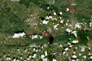
Screenshot of map of active fires in Venezuela (Prodavinci)
The digital site Prodavinci emerged in 2008 as a personal blog of Venezuelan economist Ángel Alayón. Later, it evolved into what the same team defines as "a space for ideas, conversations and debates." The site currently receives an average of more than one and a half million visits per month.
Prodavinci plans to continue carrying out projects using remote sensing and satellite data to address environmental and social issues. For now, as part of a second publication of the Nature in Flames project, it created "Where is there fire in Venezuela?" a tool that displays active sources of fire that have been detected and processed by NASA in near real time.
The hotspots are automatically updated every 24 hours with public data available on NASA's Fire Information for Resource Management System (FIRMS) page.
The map also shows all the national parks, natural monuments and other pProtected aAreas in the country. According to the media outlet, it is a tool designed so that civil society, firefighters, park rangers, environmentalists, students, journalists and scientists, can detect and monitor fires within the most important natural areas of Venezuela.


